中国大陸五万分の一地図集成

中国大陸五万分の一地図集成

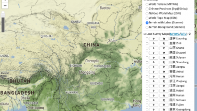
The WebGIS Platform of Historical Maps of China, conducted by the history department of Shanghai Jiao Tong University (SJTUMAPGIS), is a combined GIS system and historical scholarship on historical maps of China to geo-reference scanned maps by ArcGIS and release them for public use. This is an open and nonprofit platform for sharing resources on Chinese historical maps.

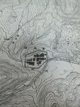
This project first focused on military maps of premodern China. All maps are scanned at high resolution (600dpi), and then geo-referenced. The WebGIS platform now contains 4,088 maps, taken from《中国大陸五万分の一地図集成》Maps of China (The Scale of a One to Fifty Thousand) (Tokyo, 2002). These maps were charted in the late nineteenth century for military purposes, covering nineteen major provinces of the main territory of China—Fujian, Guangdong, Guangxi, Guizhou, Yunnan, Hainan, Hebei, Hubei, Hunan, Jiangsu, Jiangxi, Liaoning, Shanxi, Zhejiang, Anhui, Henan, Inner Mengolia, Shaanxi, and Sichuan—with geographic elements such as cities, villages, rivers, lakes, and mountains in great detail.

The project aims to set up visualized and analyzable spatio-temporal layers on the WebGIS platform. For further project expansion, more detailed maps would be introduced and geo-referenced, including 1:25,000 scale maps nationwide and other compatible regional series maps.


Resources

LoGaRT WebGIS map example

"Visualizing Geographies of Late Qing and Republican China" Workshop

News & Press

Research project "Web GIS Platform of Historical Maps of China" receives SSHRC Connection grant

More

MPIWG at International Conference of Digital Archives and Digital Humanities (DADH), December 1–4, 2020

More

Past Events

Visualizing Geographies of Late Qing and Republican China: A CHMap Workshop

MORE

Publications

Lin, Nung-yao, Shih-Pei Chen, Sean Wang, and Calvin Yeh (2020). “Displaying Spatial Epistemologies on Web GIS: Using Visual Materials from the Chinese Local Gazetteers as an Example.” International Journal of Humanities and Arts Computing 14 (1–2): 81–97. https://doi.org/10.3366/ijhac.2020.0246.

Read More

Lin Nung-yao 林農堯, Chen Shih-Pei 陳詩沛, Che Qun 車群, Yeh Calvin 葉桂林, and Sean Wang (2019). “Shuwei renwen zhong de kongjian renshilun: yi Zhongguo fangzhi yu lucetu weili 數位人文中的空間認識論: 以中國方志與陸測圖為例 [Spatial Epistemologies in Digital Humanities: Using Local Gazetteers and Land Survey Maps of China as an Example.” In DADH 2019: Di shi jie shuwei diancang yu shuwei renwen guoji yantaohui: huiyi lunwenji 第十屆數位典藏與數位人文國際研討會: 會議論文集 [DADH 2019: 10th International Conference of Digital Archives and Digital Humanities: Proceedings]. Vol. 12(3-6), 143–159. Taibei: Guoli Taiwan shifan daxue. https://dadh2019.conf.tw/site/page.aspx?pid=305&sid=1308&lang=en.

Read More

Related Projects